The area around Guatemala City is elevated, mountainous, and volcanically active. One of the most prominent of the volcanoes in this area, Fuego (Spanish for “fire”), has been erupting regularly and has recently produced enough ash to close the airport in Guatemala City about thirty miles away. Right next to Fuego lies Acatenango, a dormant volcano from which hikers can obtain a stunning view of the eruption from less than two miles away. It’s not an easy view to obtain though, because unless you hire a helicopter, you’ll have to hike eleven miles round trip with a pack full of water and cold-weather clothes to the summit, where the eruption can be seen. Even without the added twenty-to-thirty pounds of backpack, climbing up the 5,150-foot elevation change on volcanic gravel trails would be tough.
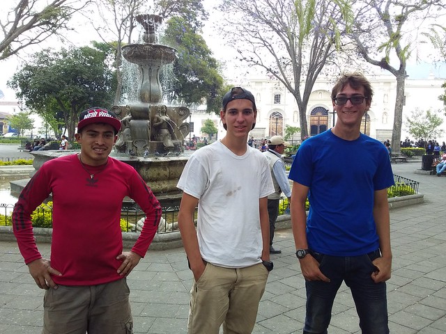
On a recommendation from some friends, and because we knew we didn’t want to miss such a cool opportunity, we decided to do it during our week-long visit to Antigua in April. After talking over what we knew about the hike, it was apparent that the whole family would not be going on this excursion. We reached the conclusion that only Eli and I would go with Walter, a trusted guide recommended by Joaquin, a friend of ours who had previously done the hike with him. We each packed five liters of water, some snacks, and all the warm clothes we own. We would be hiking about five hours up to base camp, then remaining there until 4:00 AM, when we would be getting up to hike the remaining hour and a half to watch the sunrise from the peak. At an elevation of 13,045 feet, the temperature can drop below freezing and the wind chill can be wicked, though it seldom rains or snows due to lack of moisture.
We met Walter at the Parque Central of Antigua at 7:00 AM, said “adios” to Mom and Dad, and followed Walter to the bus terminal. The first bus took us to a neighboring town outside the old city from which we rode a second bus to a town lying at the foot of Acatenango. There Walter made some last-minute preparations, then we rode in the back of a truck up to the trailhead. We disembarked from the truck, bought hiking sticks for five Quetzales apiece (less than $1), shouldered our packs, and started hiking around 9:30 AM.

The first part was probably the worst, because it took about an hour for us ascend the dusty trail that runs between cultivated fields before we started getting any shade—we were prepared for cold, but not for heat. From there we basically trudged uphill for four more hours until we reached base camp. The scenery was actually quite nice, but when we weren’t resting, all we really cared about was making it as far as possible before we had to stop again.

We were by no means the only ones doing this; we saw several other groups going up and several more going down from the previous day. The last part of the hike to base camp was probably the best (that and bumming around base camp just watching the volcano) because it was mostly flat. Base camp consists of several terraces in the mountainside where rows of tents can be set up.

We arrived around 2:30 PM and were immediately presented with an amazing view of Fuego. We set down our packs, sat down, and watched for a while as occasional plumes of ash and smoke billowed from Fuego like a chimney. Every once in a while we’d be able to hear it exploding and see chunks of rock go flying. But most of the time there was not much more to see than some cool cloudscapes. We decided that clouds are only interesting from above; from below you only get to see the flat bottoms.

Up to this point we had been wearing pants and T-shirts and had been rather hot. Now that we had ceased our strenuous exercise, we started packing on the layers. We helped Walter pitch our tent, then we took a little nap until it came close to sundown when we put on more layers and went to watch the sunset from a nearby vantage point. We took pictures of ourselves in front of Fuego, but it refused to erupt dramatically as long as we were holding the camera. It was still a sweet view, pretty high up on the list all the awesome things that I’ve seen. Erupting volcano? Yeah, definitely in the top three.
It got better after dark, because it was possible to see more color than in daylight. When it erupted, we didn’t just see clouds of ash, we also saw the reddish orange of the glowing lava spewing out from the top of the barren rock cone set against the darkening evening sky. It really was that dramatic; I’m not exaggerating. It was just like the cover of a national geographic magazine, with little orange lava particles being ejected with considerable force from Fuego just a few miles away. Unfortunately it was impossible to capture pictures that reveal what it looked like—when we tried to photograph fountains of lava, all we got was black background with orange splotches.
We sat around the fire with some people from a different group, ate dinner with the erupting volcano in the background, and then went into our tent to sleep. Or so we hoped. The hours between 8:00 PM and 4:00 AM ticked by agonizingly slowly. Neither of us could have gotten more than four or five hours of sleep and certainly not uninterrupted. The most probable reasons were the lack of pillows, the cold, and a mental giddiness caused by our location. Once during the night I became sick and spent some time outside the tent, though even now I can’t imagine why, because I felt fine afterwards.
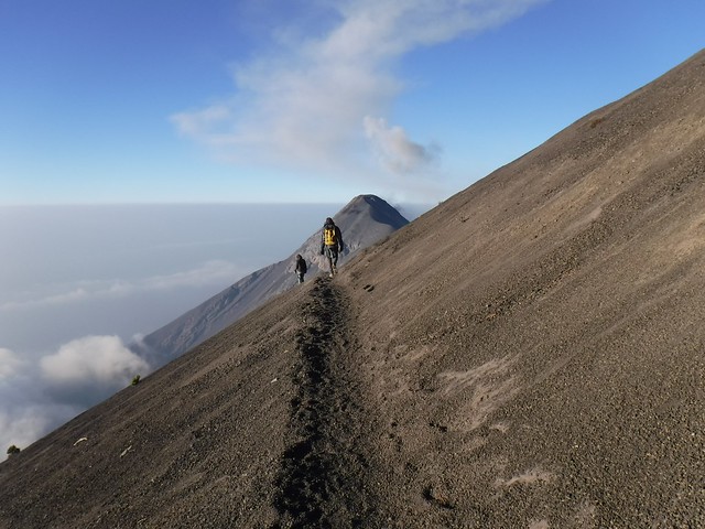
We were awakened in the dark of early morning for the final push to the summit. Eli and I removed most of the contents of our packs to make them lighter, put on all of our extra clothes, and continued the upward journey. Not too long after we started, a little bit of light was visible on the horizon and we ascended past the tree line. There was no longer any vegetation at all, just black pumice for the rest of the way. The last stretch was possibly the most grueling hundred yards that I have ever traversed. Combined with lack of sleep and fatigue from the previous day, the almost 45° incline and the sliding gravel ensured that each step was as tortuous as possible.
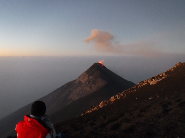
The first thing I did when I got to the top was lie down and enjoy the view (and also the fact that there were no more uphill slopes in my near future). And the view was indeed worth all the trouble; from an elevation 13,045 feet we were actually looking down on Fuego, which was 700 feet below us at a height of 12,346 feet. We were also considerably higher than the clouds, which created a flat grey plane covering the ground below us. It was quite stunning.

And the volcano was even better, because we could still see all of the color, but also much closer and from a different angle. We could see it explode upward then fall and ooze down the side. We were not the only ones to see it; after a while there was actually a bit of a crowd—maybe twenty to thirty people around one of the more prominent viewpoints.

It was also really cold. Not just the temperature but also the wind chill had us freezing inside all of our layers within fifteen minutes. Not what you might imagine of tropical Guatemala. We drank some blessedly hot tea that Walter had brought in a thermos, took some triumphant photos, and just generally enjoyed our sense of accomplishment. The top of the volcano on which we stood looked like the surface of another planet: only black gravel, pale dawn sky, several mounds surrounding a central crater, and a white metal shelter constructed as a memorial in the middle of the crater, looking like a habitation module from Earth. I also felt kind of like an astronaut in all of my layers, standing against the harsh, cold, alien wind.
After a little while, Walter suggested that we start down, so we picked up our packs and followed him back down. We took a slightly different path down which made it possible for us to basically run straight down. If I’d had a snowboard or something, I probably would have been able to ride it on the loose material. At any rate it was fast, fun, and not too hard on the ankles. Upon our return to base camp, we changed into lighter clothes for the hike down, ate a quick breakfast, packed up, and started walking. We were the first to start hiking, and only passed one solitary hiker near the trailhead who was the first person coming up for the day. It was all downhill and we ran some of the way, covering the same distance as the day before in less than half the time.
Five minutes from the end though, Eli and I both suffered the only injuries we received on the entire trip. Eli slipped and ripped his jeans, and I, in classic Aaron-fashion, tripped and landed face first, cutting my lower lip. It looked kind of messed-up for almost a week afterward. After quickly self-administered first aid, I rejoined the other two, and we took the truck and bus rides back to Antigua, where we met Mom, Dad, and Sam. We took leave of Walter and finished our trip with celebratory pulled-pork sandwiches at Pappy’s BBQ and went home for much-needed showers and naps.