Author Archives: Jay

Generator Teardown, Day 1

The job for today was to separate the generator part from the engine part.  The kids undid all the bolts on the isolation mounts, the stator assembly, the rotor, and flywheel housing.  They also removed the engine wiring, alternator belt, and some of the hoses.  Grownups were needed to take the bolts off the flywheel with an impact wrench and to physically move the (really, really) heavy stuff out of the way.

Mounts

The Back End

Flywheel

Naked

Grease Monkeys

Diesel Camp

Our generator is dead.  We had it checked out, and the windings are shot.  Even though the engine part still works, repairing or replacing the backend doesn’t make sense compared to just getting an entirely new machine.  

So the old one has been removed and I’ve begun shopping for a replacement.  Removed is such an easy word to say, but it was not an easy thing to do.  A Northern Lights 12kW genset weighs over 800 pounds.  It took a series of lifts with a chain hoist and an I-beam to move the thing from the boat to the dock, onto a cart, and then into a truck.  I’m sorry I don’t have any pictures.  Whenever those 800 pounds were swinging in the air I always seemed to have something else on my mind.

Usually a failure like this is an opportunity to rethink the situation and make it better.  But in this case I’m not finding anything that I think needs to be improved.  The Northern Lights was a great generator.  It died from old age, neglect, and a dose of salt water.  The 12kW was way overkill, so I think the next one will be about half that size.  Otherwise, I’d go right back to the same thing… if it weren’t for the cost.  Northern Lights generators command a hefty premium, so instead I’m looking at the Kubota-based sets from Phasor and Beta Marine.

For the same reasons that I can’t repair the old generator, I can’t really sell it either.  So what do you do with a working engine that is not useful or valuable?  Let the kids take it apart, of course!  The kids are going to diesel engine camp this summer.  They’ll dissect it under Ben’s tutelage and then put it back together.  I’ll get some pictures of that for sure.

Going Synthetic

We’ve been experimenting with Dyneema line lately.  Technically known as ultra-high molecular weight polyethelene (UHMWPE), the stuff is stronger than steel, yet soft and light.  It’s been around for a while and is gradually replacing wire rope in industrial applications.  Relatively new for recreational use, it is becoming more prevalent for low-stretch halyards, lifelines, and is even growing in popularity for standing rigging (ie. holding up the mast) on performance-oriented boats.  

We already have Dyneema-cored halyards and jib sheets, and when we replaced our running backstays a couple years ago, we switched from wire to Dyneema there.  Eventually we’re going to change our lifelines over, and probably our lazy jacks, too.  In a couple years we’re going to need a full rig replacement, and I hope to be able to make a good decision between staying with wire or going all synthetic.

Softies

Another use for Dyneema is replacing steel shackles, and this has been the focus of our recent experimentation.  Soft shackles, as they’re called, are easy to make and there are many sites online that show you how.  Sarah can do one in about 30 minutes with $3 of materials, and yet they typically sell for $20-30.  She has already realized that the profit margin splicing rope beats the heck out of a lemonade stand.

What we want now is to break a few of them to confirm their theoretical strength.  But it’s not that easy to do.  I think that loop pictured above might take 12,000 pounds.

Ultimately, I want to use Dyneema shackles to attach our anchor bridle to the chain.  Currently we tie the bridle legs on with rolling hitches, but that takes time to do and undo, and is failure prone.  Chain hooks don’t do it for me either.  I like to sleep at night and a Dyneema shackle a couple times stronger than the chain will do nicely, especially when I can throw on a backup for a few bucks and some child labor.

Yard Work

We value hard work and it’s something we try to teach our kids.  But whenever we try to get them to buckle down to heavy duty schoolwork or chores, all we seem to get is bitching and moaning.  

We’ve long felt that what was needed was a lesson in good hard physical labor, so I mentioned our dilemma to a friend in the process of clearing his new property.  It happened that Ben had just cut back a Brazilian pepper hedge, had a huge pile of trimmings, and had rented a wood chipper for the weekend.  He was estimating about 8 hours of work for he and Paul, with one of them on the chipper and the other hauling branches.  We decided it would be a great opportunity for the kids to help out and get a taste of real work.

It took one hour.  I worked the pile, separating braches.  The four kids hauled branches from the pile to the chipper.  Ben fed the chipper non-stop, and Paul prepped the bigger branches with a chainsaw.  

The kids performed well beyond my expectations.  While I had planned for the work to last a little bit longer, they went at it with such dedication and teamwork that I couldn’t be anything but pleased.  There was no whining, no complaining, no ass-dragging.

I’d arranged for Tanya to pick us up after three hours, so we had a little time to kill.  While we were waiting, Ben taught the boys to operate the backhoe and let them use it to dig a big hole.  They were in boy-heaven.

Waterspout

The weather had been nasty all day, so it wasn’t a huge surprise yesterday to look up and see a waterspout.  

Waterspout

They’re not common, but we’ve seen a few of these before.  Eli is our official historian and he says four waterspouts in the last three years.  So our initial response was more of the “oh, cool” variety.  Usually they don’t last very long and don’t head our way.  But this one was doing both.

We were anchored off of New Plymouth at Green Turtle Cay and the waterspout appeared to be in Black Sound.  It would have to cross land to get to us and at that moment I was cherishing a belief that waterspouts can’t cross land.  But this one was doing an admirable job.

Waterspout Ashore

The swirling cloud of dirt and debris was quite mesmerizing.  We even saw it pick up what looked a whole lot like a roof.  It was about this time that we began to think “oh, crap”.

There are two kinds of waterspouts.  Most of them are non-tornadic.  They’re relatively weak, relatively stationary, and have a very small area of influence.  Not that you’d want to be in one, of course.  They’re just not as deadly as their land borne tornado cousins.  The second kind of waterspout is.

This turned out to be the first kind fortunately, but it was kind of dicey for a while.  It eventually dissipated over land, but the weather was really weird for the next 10 minutes.  A 30 knot wind came through the harbor and spun all the boats around 360 degrees.  

And then it rained.

Remora

Take Two usually has a habitat of little fish living beneath her.  They like the shade and the edible tidbits that rain down at meal times.  We call them the cleanup crew.  

In Marathon, they’re little snappers.  In Bradenton and Ft Pierce they’re catfish.  In the Bahamas… nada.  No fish.  It’s been kind of sad and lonely not to have any little friends down there cleaning up after us.

So it was remarkable in Royal Island a few weeks ago when Tanya scraped a plate overboard and little fish came out from under us and snapped up the goodies.  Remarkable because he was an odd little black and white shark-looking fish, and because, hey, it was a fish!  We commented that he kind of looked like a remora, and then we thought nothing else about him.  The next day we sailed to the Abacos.

Fast forward almost a month and a couple hundred miles.  This afternoon as I scraped a plate at Green Turtle Cay, guess who popped out?  If it isn’t the same fish, it’s one EXACTLY like him.  It is definitely a remora.  I don’t have a great picture of him yet, but we can clearly see the sucker on the top of his head.

Remora

So what are the odds that it’s the same fish?  Well, when was the last time you saw a remora in real life?  Doesn’t exactly happen every day, does it?  And isn’t it a remora’s purpose in life to stick himself to a bigger fish and live off its scraps?  Where is his big fish?  I think it’s us.

So we have a little buddy.  This is so much better than the usual ragtag band of loafers we attract.  I wish we could keep him forever like a pet.  Unfortunately, we’re headed for a dock in Florida and I don’t think he’s going to like the locals very much.  But for now he’s got a pretty good thing going.

Iguana Hunt

Our kids are incorrigible lizard hunters.  Cubans, skinks, curly tails, green and brown anoles, even iguanas; a lizard seen is a lizard chased.  One of the things they really wanted to do on our trip to the Exumas was go back to Leaf Cay.  

Leaf Cay is known for its iguana population.  Go-fast boats full of pasty tourists make a daily run from Nassau to see them and, predictably, the iguanas have gotten used to being fed.  The kids were counting on this and came prepared with food — well… bait, actually.

The iguanas were unprepared for a coordinated assault from four boat kids.

Iguana Hunter

Island Fire

Our kids love a beach fire and are always on the lookout for a suitable place to make one.  Unfortunately, it isn’t that easy to find. 

First there are the physical requirements: sand and wood.  Much of the shoreline in the Bahamas is a rocky marl, or “ironshore”.  Not a place you want to land your dinghy.  The island must have trees from which to gather firewood.

It must be near a place we want to park Take Two for the night, and the way back home must be navigable by dinghy at night.  Finally it can’t be inside the Land & Sea Park, or on a private island, and I don’t really want it visible by anyone else at all.  So we’re not exactly overrun with opportunities.

At one point during our trip, we were anchored south of Compass Cay and thought we had found a good location for a beach fire on a neighboring island.  It had been a busy day, and we weren’t planning to move the next day, so we decided to defer the fire.

That night someone was shooting fireworks from the vicinity of the marina on Compass Cay, probably from one of the big fancy yachts in there.  After a long day of zooming around on jetskis, fireworks and loud music are the perfect way to unwind.  The show appeared to be over, but then Sam alerted us that now they were having a bonfire!

Compass Cay Fire

Clearly it was no bonfire, but a fireworks-induced brushfire somewhere between us and the marina.  We watched it rage for hours beyond the ridge of the island nearest to us.  The breeze was strong and it was helping the fire spread nicely.  We tried to determine exactly where it was in order to predict the extent of the potential damage, but in the dark it was difficult to tell.  Eventually the fire burned low and we went to bed, expecting evidence of it to be readily apparent the next morning. 

But it wasn’t.  Either by dinghy or by climbing Compass Peak, we could find no trace of the fire, though we could still occasionally get a whiff of it on the wind.  In any case, it seemed that it was no longer the time or the place for beach fires.

A few nights later, near Sampson Cay, the kids finally got their beach fire.

Bahamas Again

We came with very few goals except to hang out in the Exumas and have some fun.  I had a long-standing promise to the kids I needed to make good on, and two of Tanya’s Top 10 favorite places on Earth are here.

So far it’s been a bit of a reunion tour since we’re unintentionally retreading old ground.  Weather avoidance is de rigueur in the northern Exumas and we’ve been calling on prior experience to find effective shelter.  Things are a little different this time since we have a full-blown SSB transceiver to get weather forecasts, which allows us to plan ahead instead of being entirely reactive.

We checked in at Chubb Cay, which was new for us.  I think a lot of people eschew Chubb because of their $100 landing fee.  They offered to let us put it against fuel, but I declined.  I understand they’ll also put it against dockage, but we wanted to keep moving.  So with the $100 landing fee, the $10 bus ride to the airstrip, and $380 at customs, we were legal.  It was a convenient place to stop and we’d do it again, but otherwise I didn’t see anything to write home about.

We have more avid and capable snorkelers this time.  During our weather-bound stay at Highborne Cay, we did another family snorkel at the Octopus’ Garden.  It’s much less stressful not having to worry about little kids, and it’s really convenient having four spotters wanting to show me all the best parts, but anybody who has taken a nature walk with a bunch of kids knows they’re not going to sneak up on anything.

Some local lobster pros were at work on the bar between Highborne and Leaf Cays while we were there.  Lobster season here ends 3/31, so we figured we’d try our hand.  Eli and Aaron haven’t developed much taste for lobster yet, but they love the thrill of the hunt.  Based on our results so far, if we want lobster we’ll have to buy it.  They’re just too deep.  The pros are using air, which we’re not allowed to do.

I find myself looking for conch.  Not to take it, mind you, because foreign vessels are not allowed to do that either, and frankly because I don’t care for conch that much, but really just to assure myself that they’re still there.  Ten out of ten conch shells we see have already been harvested.  The live ones we do find are all juvenile.  Sam brought me a big conch shell today that he said was alive.  It sure was, but it wasn’t a conch inside.  Poor kid doesn’t know what the real animal looks like.  Living in that shell was the biggest hermit crab any of us had ever seen.

Mondo Hermit Crab

Now we’re at Warderick Wells in the Land and Sea Park.  So whatever might be underwater is off limits.  Internet access is via satellite and costs $10 a day with a 100MB limit for boats that are on their moorings.  We have no use for a mooring but hunger to check email.

Our plan is to be fully back online the second week of April, but our plans are always subject to change.  It looks like we may have let the magic smoke out of our main generator, so we’re trying to adjust to a leaner power budget, and balance our fuel supply with our other means of power generation.

Otherwise we’ve had few failures.  A v-belt broke on one of the engines, but we had a spare.  Plenty of food and beer left, though we’ve shut down one of the refrigerators to save power.

So far we have failed to try out the new 4G network.  If we make it as far south as Staniel Cay, which I think is the closest BTC office where we can get SIM cards, we’ll try to get that remedied.  A decent Internet connection could make a world of difference.

B&G SailSteer

I just read an article on Panbo that grabbed my interest.  It’s about how Navico is aligning its three(!) chartplotter brands (Lowrance, Simrad, and B&G) around small boat fishing, big boat fishing/cruising, and sailing respectively.  The B&G stuff looked very promising last year, but was very high-end and therefore mucho dinero.  Instead I bought a fishing-oriented Lowrance HDS-7m Gen2 because it was a brand new model, had satellite weather, and was cheaper.  The article goes on to wonder how Navico will adjust their B&G brand lineup to address the lower-end of the sailing market.

I was losing interest and beginning to skim, but then I got to the bottom and saw this screenshot.

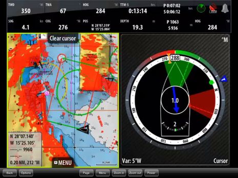
Wow!  Now that got my attention.  The layline stuff on the left is old, I’ve seen that before.  But the graphic on the right is entirely new to me.  Although now that I look, I see the press releases for it are almost 5 months, so I'm a little bit behind.  Anyway, it looks strikingly similar to a prototype I made in August 2011 and wrote about here.  The key aspect being the compass dial with indicators around it.

They call it SailSteer and its available on their Zeus Touch plotters.  From what I can tell, they’ve done everything I wanted and more.  I see the waypoint, true wind, laylines for the current and opposite tack, rudder angle indicator, and even direction and velocity of the calculated tidal current all in one place.  I’m feeling quite compelled to buy it.

I like Navico for their innovation, and am very excited about what they’re doing with B&G.  My Lowrance plotter is okay, but not great.  It isn’t any worse than I expected.  They made it for fishing boats after all.  But it can interface with their 4G radars, which are spectacular and on my wish list.  If I get a B&G for the helm, the Lowrance will come inside.  It will continue to be our source for satellite weather and radio, as well as an inside plotter and eventual radar display.

From my perspective, the big downside to Navico (and Raymarine) plotters is their use of Navionics charts and Navionics’ sub-par data in the Bahamas.  Navionics is great in the US because they (like everyone else) get the data from NOAA.  Where do they get their Bahamas data?  I don’t know, but it isn’t from Explorer Charts, which is the gold standard for the Bahamas.  Garmin licenses the Explorer data for its products.  So when we’re in the Bahamas next I may be using fancy B&G instrumentation for sailing, but I’ll be using our little handheld Garmin to reduce the chances of running into stuff.

Just last month a relatively new Lagoon 450 was wrecked on a reef in the Exumas when the skipper put too much faith in his Navionics charts.  The chart in question even has a nice magenta dotted line that looks an awful lot like a recommended route.  One look at an Explorer chart and he would have steered clear.  All the gory details including an account from the skipper and a response from the owner of Navionics can be found here.


Update 4/21/13:

I’ve learned a few things that warrant an update to this post:

First, we’ve been cruising the Bahamas with Garmin’s data (licensed from Explorer) and Navionics’ side-by-side and I’ve seen firsthand how stark the difference is.

Second, a friend pointed out that users of MaxSea/Furuno/Nobeltec products can get data through MapMedia that is from “Datacore by Navionics”.  This data for the Bahamas looks very similar to Explorer data.  Perhaps it is Explorer data, or perhaps there is a common lineage.  I’m sure Explorer must have originated from another source.

Third, Jeppesen has a new product line in its “C-Map by Jeppesen” family called C-Map MAX-N.  The “-N” is for Navico and will be available for current chartplotters from Navico brands Lowrance, Simrad, and B&G.  C-Map uses Explorer data exclusively in the Bahamas.

Explorer's own explanation of where their data is available can be found here