Category Archives: Geography Report

Geography Report: Mexico

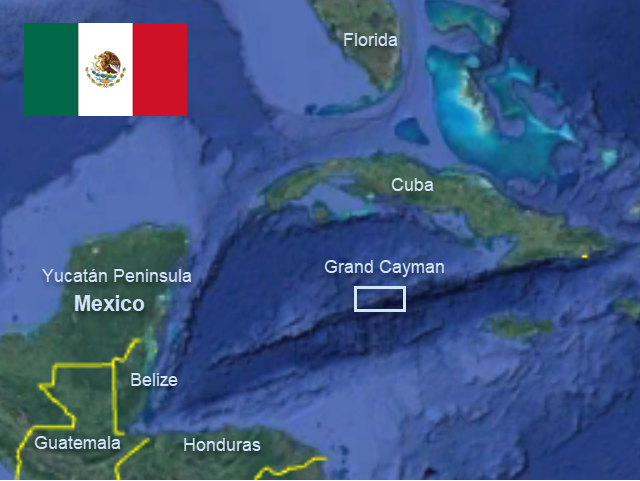
Note: This is the last of the Caribbean geography reports. As Mexico is such a large country, I have chosen to focus on the part of Mexico we visited, Isla Mujeres and the Yucatán peninsula.


Basic Facts

Capital: Mexico City

People/Customs: Nearly 30 percent of the Mexican population is indigenous (Mayan, Mixtec, Náhuatl, Otomí, Purépecha, Zapotec), 60 percent are mestizos, and the remaining 10 percent are white or other ethnicities. Most of the people practice Catholicism and even the indigenous people have mixed traditional religions with catholic practices. Most holiday celebrations include fireworks, music, and dancing. Day of the Dead (Día de Los Muertos) celebrations commemorate family members who have passed on by decorating tombs and creating elaborate alters at home.

Language: Spanish is the official language, but there are 68 Amerindian languages also spoken.

Climate: The climate zones of Mexico vary from snow-capped mountains and alpine tundra to tropical islands, making Mexico attractive to visitors looking for variety. The main regions include: tropical wet, tropical wet-and-dry, semi-arid, desert, temperate with dry winters, humid subtropical, and Mediterranean. Where we were, in Isla Mujeres, the weather was warm, sunny, and breezy with predominant easterlies, cold fronts with north wind in the winter and spring, and tropical waves and risk of hurricanes in the summer and fall.

Food/Farming: typical Mexican meals consist of corn, beans, rice, tortillas, squash, chilies, avocados, tomatoes, sweet potatoes, and a various meats, like turkey, beef, goat, pork, chorizo, and chicken. Mexico is also known for its delicious tacos. Corn has been Mexico’s most important food for thousands of years, and it has a religious significance for the Maya, Huichol and many other indigenous groups. Fruits grown in Mexico include: pineapples, citrus fruits, star fruits, mangoes, papayas, melons, tomatoes, and other tropical fruits. A popular drink is tequila, made from the agave plant.   

Government: The United States of Mexico has a Constitutional Republic, with a President as head of state.

Currency: Mexican Peso, about 18 pesos to the dollar.

Art/Music/Culture: The culture of Mexico is a mixture that comes from its history of Old and New World influences. Cultural influences include traditions from the Maya and other indigenous peoples, Spanish language, music and religion from the conquistadors and settlers, and a mixture of European, African, and Asian cultures that arrived later in Mexico. The Spanish brought Roman Catholicism, which became Mexico’s main religion and slowly mixed with the indigenous religious practices. Mexico has a rich artistic history, with world-famous artists like Frieda Kahlo, as well as arts and crafts like weaving, pottery, leather-working, and wood-carving. Decorated skulls are a common motif. Popular musical styles include mariachi and ranchera, which use the sounds of various guitars as well as violins, trumpets, and accordions.

History of the Yucatán Peninsula

The Yucatán’s oldest traces of humanity date back 11,000 years according to artifacts found in the Loltún caves and Tulum. It is supposed that the first Mayas arrived in the Yucatán around 2500 BC. The Maya had a knowledge of astronomy, math, and architecture, the evidence of which can be found all over Mexico in the form of pyramids, palaces, and other structures. The Maya were also good artists, based on jewelry, carved limestone, and plaster artifacts found at ruins.  

Around 600 AD the Maya civilization was at the height of its Classic period. The Maya lands at this time were not ruled as an Empire, but as a collection of independent city-states. Near the end of the Classic period, the Mayans moved to the Yucatán, with ruins like Chichen Itzá showing us construction very different from earlier Mayan settlements (Tikal in Guatemala, for example). After the Classic period, the collapse of the Maya came very suddenly. One theory is that as the Maya civilization grew, they were not able to grow enough food to feed the people. The Maya then weakened and were taken out when the invaders from central Mexico came.

Mexico was “discovered” by the Spanish conquistador Hernan Cortes in 1485. The Spanish came to the Yucatán in 1513 when Juan Ponce de León and Antón de Alaminos set out to find land west of Cuba and came across a large peninsula. The first attempt at the conquest of the Yucatán was made in 1527, when the Montejo family and a band of other men were sent from Spain to Cozumel, but they decided to sail around the peninsula and quell the unrest in Tabasco. They decided to establish their base near Campeche and push inland to conquer the Yucatán, but four years later they were forced back to Mexico City. In 1542, after allying with the Xiu, the Montejos defeated the Cocomes, and founded the city of Mérida. In four years’ time they had put most of the Yucatán under Spanish rule. The Mayans then became slaves for Spanish settlers.  

Throughout the colonial period, the native Maya and other indigenous groups continued to resist Spanish rule. The harsh treatment of natives by the Spanish led to many revolts, most of which were unsuccessful. In 1821, after a war with Spain, Mexico succeeded in becoming independent, and the Yucatán became part of the Mexican Federation. Despite the new government, the Maya were still forced to work under horrible conditions which led to the Caste War. In 1847, Mayan chiefs led a revolt against the descendants of Spanish settlers who had political and economic control. This act started an all-out war between the Maya forces and the Yucatecos (Spanish descendants). The war officially ended in 1901 but some of the small settlements and towns refused to acknowledge Mexican control. The war spilled the blood of over 200,000 people.

From 1876 to 1911, when Porfirio Diaz ruled Mexico, he brought the country into the Industrial Age. He passed laws that created an even larger number of landless peasants and concentrated the wealth in the hands of a smaller elite. In the Yucatán, wealth was acquired by making rope and other products from plant fibers. Diaz was removed from power in 1910 when a war broke out, sending the country into chaos for the next decade.   

By the 1970s, huge oil reserves were discovered in the Gulf of Mexico, which brought new investors to the country. With new money coming in, Mexico invested in infrastructure on a large-scale, and installed a central oil processing complex in the Bay of Campeche, which was producing a million barrels of crude oil a day by 1981. The influx of oil money also led to the development of the Quintana Roo and Cancún as tourist destinations. With white sand beaches, crystal-clear turquoise-colored water, and nearby ancient ruins to explore, this area soon became known as the “Riviera Maya” and attracted tourists from all over the world. While oil prices fluctuate, creating booms and busts, the tourism industry remains fairly constant, despite the occasional hurricane causing damage and requiring rebuilding.

Landforms/Flora and Fauna

Mexico is a large country and has a very diverse landscape. To the north is the U.S.A., to the east, the Gulf of Mexico and Caribbean Sea, to the south, Belize and Guatemala, and to the west, the Pacific Ocean. Baja California is located in the northwest, a jagged finger of land with mountains and desert bordered by the Pacific Ocean and the Gulf of California. Mexico has the world’s largest volcanic field. Central Mexico has the Sierra Madre mountains and a central plateau. Mexico City is in the south-central part of the country and boasts a population of 21 million people in the greater metropolitan area. The Yucatán Peninsula is flat, with a coral limestone bedrock covered by littoral forest and filled with sink holes, caves and cenotes. Isla Mujeres is a small island to the north of the Yucatán, surrounded by beautiful water and coral reefs. Because of this variation in land forms, the flora and fauna are found in equally diverse habitats—from pine forests to tropical jungle, from cactus-covered deserts to palm-fringed beaches, from treeless volcanic peaks to the fertile Bajío region where produce is grown. Some animals you might see in Mexico are spider monkeys, the rare axolotl (salamander), cacomistle (mammal), Mexican prairie dog, ocelot, cenzontle (bird), zoloitzcuintli (hairless dog), quetzal (bird), endangered vaquita porpoise, coati, and Mexican gray wolf. Near Isla Mujeres, you might go in search of whale sharks or sail fish, or see barracuda, snappers, colorful reef fish, and marine invertebrates while snorkeling and diving.

Things to do in the Yucatán/Isla Mujeres

On the mainland there are cenotes to explore, Mayan ruins like Chichen Itzá and Tulúm, beaches along Cancun or on Isla Mujeres, snorkeling and scuba diving along the Caribbean coast, visiting the Spanish colonial city of Mérida, horseback riding, and deep-sea fishing. Also, good tacos can be found almost everywhere!

Bibliography

“11 Awesome Native Animals You Must See in Mexico.” www.theculturetrip.com . Accessed July 2019.

“Mexico.” (Basic Facts) Wickipedia. Accessed June 2019.

“Mexico’s Seven Climate Regions.” www.geo-mexico.com. Accessed July 2019.

Onstott, Jane. National Geographic Travelor: Mexico. 2006: National Geographic Society, Washington D.C.

“Yucatán Peninsula: History.” Lonely Planet. www.lonelyplanet.com . Accessed July 2019.

Geography Report: Guatemala

Editor’s Note: After nine months in Guatemala, Take Two is preparing to head north toward Mexico–likely Sam’s last geography report–as we complete our three-year, 5000+ nautical mile circle of the Caribbean this spring.

Basic Facts

Capital: Guatemala City

People/Customs: Guatemala has a population of more than 16.5 million, (as of 2016), made up of many different people groups about 41% Ladino (mestizo), 11% K’iche, 8.3% Q’eqchi, 7.8% Kaqchike and a mixture of other Mayan and indigenous groups. Guatemala’s religious makeup is mostly Evangelical Christian and Roman Catholic, but there is also a Jewish population, as well as small groups of Muslims and Buddhists.

Language: the official Language is Spanish, but several Mayan dialects are also spoken (Q’eqchi for example). English is taught in schools, but not commonly spoken.

Climate: Guatemala is bordered by two oceans (the Pacific and the Atlantic) making it susceptible to hurricanes, volcanos and floods. Temperatures range from near-freezing at the highest altitudes, to a humid 90° on the Caribbean coast. Guatemala has a dry season and a wet season (rain depends on altitude and region) and is in the hurricane zone, though Rio Dulce, which runs inland, is considered safe from hurricanes.

Food/Farming: typical Guatemalan food consists of rice and black beans, some sort of meat (chicken, pork, beef, or fish), salad or cooked vegetables, fried plantains, and corn tortillas. The volcanic soil of Guatemalan highlands helps with the growing of tropical fruits (bananas, mangoes, pineapples, papayas, melons, etc.) and vegetables (lettuce, cabbage, carrots, tomatoes, potatoes, corn, and beans). Cattle, pigs, and chickens are raised for meat, and freshwater lakes provide fish. Guatemalan coffee of the mountain regions is exported all over the world.

Government: Guatemala is a constitutional democratic republic with a president.

Currency: the Quetzal (1 dollar= about 7.5 Quetzals)

Art/Music/Culture: the music in Guatemala was influenced by the Spanish settlers, the African slaves, and the Mayan natives. Some of the main musical types are nueva cancion, salsa and punta. Mayan musical instruments included drums, horns, and flutes, and a wooden xylophone called a marimba is still popular today. Carvings from wood, stone, and jade are common, and the markets in the mountain regions which sell colorfully-dyed and woven cloth are famous.

History

As in Belize, the Mayan civilization plays a large part in Guatemala’s history. The Mayans were in Guatemala thousands of years before the Spanish conquered their land. It was an advanced civilization with a written language and a complex religion consisting of many different gods and spirits. The Mayans were expert builders and possessed advanced knowledge of mathematics and astronomy. They also believed in an afterlife where humans who were sacrificed continued the battle of good and evil. When the Spanish came to Guatemala in 1519, they tried to convert the Mayans to Christianity, but only succeeded in a limited way. As the Spanish settled in Guatemala, the Mayans were either killed, enslaved, or forced to flee to remote places. Many fought back, and many died of diseases brought from Europe. Since no gold or silver was found in Guatemala, the land and its people—as slave laborers—were exploited for tobacco, chicle, cacao, cotton, indigo, and cattle. Somehow, despite Spain’s three centuries of brutal rule, and continuing conflict with the Guatemalan government, their culture has survived until the present day.

The first capital, Villa de Santiago de Caballeros was founded in 1527 (present-day Antigua). After flooding and earthquakes destroyed it in 1773, it was moved to its present location (Guatemala City). During the colonial period, power was concentrated with Spanish landholders and the Catholic church, and the subjugation and persecution of the Mayan peoples that began in this period continued into this century.

In 1821, several Central American regions, including Guatemala, claimed their independence from Spain and formed a loose federation of states. In 1838, the Honduran and Guatemalan leaders of a liberal party invaded Guatemala, took over the government, and executed the head of state, beginning more than a century of violence and political strife as liberal and conservative factions fought for government control.  After warring with neighbor states, Guatemala declared its independence as a nation in 1847, though border disputes persisted into this century.

Coffee was brought to Guatemala by Jesuit missionaries in the mid-1700’s as a decorative plant but was not grown as an agricultural product until the mid-1800’s when the natural dye companies went out of business due to the invention of synthetic dyes. There are eight distinct coffee growing regions in Guatemala today and its coffee is exported all over the world.

In 1904, the United Fruit Company entered the scene, and eventually bought about 40 percent of Guatemala’s land, cultivating 14,000 acres of land with bananas and other tropical fruit, and building railways, roads, ports, and a fleet of ships. The United Fruit Company had a hand in many other business and political ventures. (The fruit companies still have a lot of economic and political power.)

Jorge Ubico was a general in the Guatemalan army who was elected president in 1931 (in an election with no other candidates) during the Great Depression after José María Reina Andrade, Manuel María Orellana, Baudilio Palma, and Lazaro Chacón had all been deposed for separate reasons in the previous 2 years. Ubico was known by his efficiency and cruelty; he reinforced the police and military greatly and instated forced and slave labor. He was forced to resign 1944 after a series of violent uprisings.

A new constitution was made which allowed all adults the right to vote and limited presidents to serving one term in office. Ubico’s successor lasted only one year. In 1945, Juan José Arévalo was elected and served a six-year term, survived 25 coup attempts, and established a social security system and health reforms. After Arévalo, a military leader, Jacobo Arbenz Guzmán was elected and made socialist reforms. Because he was friendly to the communist party and passed agrarian reforms which redistributed land to Mayan peasants, he lost the support of the United Fruit Company and incited the United States to get involved. Guzmán stepped down in 1953 before the CIA could mount an attack to depose him, and what followed was thirty years of economic and political troubles during which the constitution was revoked and the Mayans lost land holdings and civil rights. President Armas, supported by the United States, was shot by his own body guard in 1957.

After much turmoil, General Fuentes took power, but was later overthrown when the U.S., fearing a communist revolution, backed a military coup and a new leader. The next several years saw constant change and conflict—with the military in charge of the government and guerrilla fighters representing the people involved in a bitter, decades-long civil war.

Initially, the two sides were the FAR (Rebel Armed Forces) and PGT (Guatemalan Labor Party) against the MLN (National Liberation Movement), a right-wing organization aligned with the military and blamed for using political assassinations and death squads to silence opposition. Later, as the violence escalated, URNG (Guatemalan National Revolution Unity) and the EGP (the Guatemalan Army of the Poor), whose motto was “Long live the poor, death to the rich,” opposed the ESA (Secret Anti-Communist Army), FNO (National Opposition Front) and the government-sponsored PACs (Civilian Self-Defense Patrols). People were forced to either serve the government or join the guerrillas.

Horror stories and human rights abuses were common during the war. In one case, villagers who came to a town meeting to resolve a land dispute (over a parcel near fruit shipping lanes owned by the president) were met by soldiers who shot over a hundred men, women, and children and buried them in mass graves that the army had dug the day before.

The elections of 1990 were the first peaceful transfer of a civilian democratic government, and peace accords were signed in 1996. The thirty-plus year civil war cost hundreds of thousands of people their lives and land and created over a million refugees. Tens of thousands went “missing” (like school children abducted to serve in the army) and their whereabouts were never discovered. Some of those responsible (like Rios Montt, president in the early 80’s) were later charged for what amounted to genocide and “crimes against humanity.” Political turmoil, government corruption, and economic inequality are still common in Guatemala, where there is a huge gap between rich and poor, and the military protects the government instead of the people. Peace is tenuous, and there is always the threat of impending conflict. Despite that fact, Guatemala is a beautiful country with fruitful land, kind and friendly people, and a rich pre-Colombian history.

Land forms/Flora and Fauna

Guatemala is made up of volcanic mountains, cloud forests, rain forests, coastal plains, wetlands, and mangrove islands. On land you can find many different kinds of wild cat (like jaguars, panthers and mountain lions), tapirs, monkeys, coati, iguanas, snakes (including the infamous fer-de-lance), as well as domesticated animals like cows, horses, goats, pigs and chickens. In the air you can find many different species of macaw and parrot, toucans, oropendolas, hummingbirds, hawks, and vultures, as well as seabirds like pelicans, cormorants, sea gulls, and frigate birds. And In the water you can find several spices of freshwater fish like snook and white-fish, and on the coast, reef fish and sharks. There are pine forests, tropical forests, palm trees (like coconut palms), fruit trees like mango and papaya, ferns, air plants and hundreds of species of orchid.

Things to do

Go zip-lining, kayaking, wake-boarding, hiking, swimming in water-falls and hot-springs near Rio Dulce and Lake Isabal, climb a volcano, visit coffee plantations, or find jade and fabrics in the markets of Antigua, visit the Mayan ruins of Tikal or Yax’ha in the Peten region, or visit the villages along the shores of Lake Atitlan.

Bibliography

“Guatemala.” Wikipedia. January 2019.

“BBC News Timeline: Guatemala.” News.BBC.co.uk. January 2019.

Pavlidis, Stephen J. Cruising Guide to the Northwest Caribbean. “Republica de Guatemala.” 2014. Seaworthy Piublications, Cocoa Beach, FL.

Geography Report: Belize

Basic Facts

Capital: Belmopan

People/Customs: The population of Belize is 387,879, of which more than half are are Mestizo, a quarter are Creole (descendants of white Baymen and their black slaves), more than a tenth are Mayan, and the remaining small fractions are Garifuna, German-speaking Mennonites, Europeans, North Americans, and Chinese. A large percentage of the people are Roman Catholic or Protestant, but there are also small percentages of Jews, Muslims, Jehovah’s Witnesses, Mormons, Mennonites, Seventh-Day Adventists, and practitioners of traditional Mayan and African religions. (Garifuna are the descendants of black slaves and Carib natives which were relocated to Belize from the Bay Islands, where they had been brought from St. Vincent. They have their own distinct music, language, dress, and religion.)

Language: English is the official language, but an English creole, Garifuna, Mayan dialects, and Spanish are also spoken.

Climate: Belize has a dry season and a wet season and is inside the Hurricane zone (June-November). Cold fronts moderate the temperature and bring wind from North America during the winter and spring, and tropical waves bring heat and humidity from the Atlantic Ocean and Caribbean Sea during the summer and fall. Average temperatures in the coastal regions are between 75 and 80 degrees Fahrenheit.

Food/Farming: typical dishes consist of rice, beans, cabbage or salad, corn tortillas, and some sort of meat (pork, chicken, beef, or seafood). The Fyffe’s fruit company exports Belizean bananas to Ireland and the U.K. Other tropical fruits like pineapples, oranges, and mangoes are grown in Belize. Cacao is grown and processed into chocolate. Coconuts are also common, and coconut milk is used for drinking and cooking. Sugarcane is grown for local use and export.

Government: Belize became an independent state in 1821. Though it is no longer a British Crown Colony, the Queen is still the symbolic head of state of Belize, which is a parliamentary constitutional monarchy. The Prime Minister is the head of the government and there are two houses in the National Assembly, which makes laws. There is an independent judiciary and a Supreme Court for hearing serious cases.

Currency: the Belize dollar (BZD), equivalent to about $0.50 USD.

Art/Music/Culture: The culture of Belize is influenced by its many ethnic groups, among them the British, Spanish-speaking Mestizos, Mayan tribes, African slaves, Garifuna people, German-speaking Mennonites, and American expats. One popular type of music is called “punta rock,” a hybrid of soca, calypso, reggae, salsa and meringue. There are also traditional Garifuna drumming groups. Artisans carve wood and slate, make pottery, embroider cloth, make beaded necklaces, and weave baskets.

History

The Mayan civilization plays a large part in Belize’s history. The Maya settled in Belize starting in about 1500 BC, and there were as many as 1 million people living in Belize during the late Classic Era of Mayan civilization (600-1000 AD). When the Spanish arrived in the early 1500’s, there were three distinct Mayan territories (each with its own dialect which persists to this day). The Mayans believed that the world was flat, and they believed in many different gods, so when the Spanish arrived, they tried to convert the Mayans to Christianity. They were largely unsuccessful, though some Catholic concepts were added into the Mayan religion.

When the conquistadors arrived in Belize, they claimed it for Spain but did not develop settlements because of the lack of resources and the hostile Indian tribes of the Yucatan. In the 1600’s, the British wood-cutters started to come and settle the land. In 1763 and 1783, the Spanish granted land to the British wood-cutters but still retained sovereignty until 1786, when the British started to take control of the area that is now Belize in order to protect themselves from incoming Spanish settlers. In 1798, the Spanish sent a fleet to remove the British Baymen, English and Scottish settlers and pirates, using force, which resulted in the battle of St. George’s Caye. On September 3-5, the Spanish tried to barge their way through Montego Caye shoal, but were stopped by the British defenders. And on September 10, the Baymen repelled the Spanish fleet again in a short engagement with no known casualties.

By the early 19th century the British sought to reform the settlers and abolish slavery, but because of social and economic limitations, the lives of the imported blacks changed little after emancipation in 1833, and they were still used as the labor force to harvest logwood, which was used in the dyeing of cloth, and Mahogany, a hardwood. In 1836, Central America became independent from Spain and the British claimed the right to administer the area. It officially claimed Belize in 1862 as a British crown colony and renamed it British Honduras.

In the years 1847-1853, many thousand Spanish-speaking people started to settle the area resulting in the Caste War in Yucatan, causing the Mayans to flee to the west and the north and allowing the Spanish-speaking refugees to colonize Belize.

The Belize Estate and Produce Company dominated the politics and the economy for much of the late 19th and early 20th centuries, with British landowners holding half of the colony as privately-owned land. The economy collapsed after the Great Depression, when demand for mahogany went down. Soon after, there was a devastating hurricane, which worsened the economic situation. Unhappy with British management of the colony, the colonists began to demand independence. By 1964, a new constitution gave Belize full autonomy. In 1970, Belmopan replaced Belize city as capital and in 1973, British Honduras changed its name to Belize. Belize claimed its independence from Great Britain in 1981, though it is still considered a Commonwealth nation. Guatemala, which had never accepted British control, refused to recognize that Belize was a sovereign nation until 1992, claiming that the entire country was actually part of Guatemala. The border disputes have been contentious and continue to the present day.

Today, Belize’s reef, tropical islands, and rain forests make it a perfect vacation spot. Many North Americans have migrated to English-speaking Belize and made it their home. In 2006, crude oil was discovered near Spanish Lookout, and Belize exports crude oil but imports diesel and gasoline, since it has no refineries. Belizean bananas and oranges are also exported around the world.

Land forms/Flora and Fauna

Belize has a land area of 8,800 square miles, and the second largest barrier reef in the world. It also has hundreds of mangrove islands, barrier islands, and vast areas of marshy wetland. The Maya mountains have rivers and waterfalls and are covered in rainforest. On land you might find jaguars, the national animal of Belize, along with many other large cats, agoutis, tapirs, iguanas, and snakes. In the air you might see toucans, quetzals, sea-birds and many different species of parrot and macaw. In the water you might find whale sharks, tropical fish, turtles, and manatees.

Things to do

Hiking in the Jaguar Preserve, going to the Bunches of Fun Banana Farm near Placencia, white-water rafting, river tubing, or cave tubing, snorkeling or diving on the reef, zip-lining, kayaking, fishing, taking a boat tour up the Monkey River, and going to the Mayan ruins like Caracol, Xunantunich, or Nim Li Punit,

Bibliography  

“Belize.” Wikipedia. June 28, 2018.

“Belize: the Arts.” Encyclopedia Britannica. June 28, 2018.

Rauscher, Freya. A Cruising Guide to Belize and Mexico’s Caribbean Coast. 2004: Windmill Hill Books, Madeira Beach, FL.

“Timeline: Belize.” BBC News online: www.news.bbc.co.uk . June 28, 2018


Geography Report: Honduras and the Bay Islands

Basic Facts

Capital: Tegucigalpa is the capital and largest city of Honduras. Roatan is the capital of the Department called Las Islas de la Bahia which includes the Swan Islands, Guanaja, Roatan, Utila, and the Cayos Cochinos.

People/Customs: The population of Honduras is 9,112,867 while the Bay Islands’ population is 65,932. There are many different people groups living in Honduras, such as the indigenous Chortí, the Copán, the Lenca, the Jicaque, the Pech, the Tawahka, and the Miskitos of the coast, which have a mixed heritage including British and African. There are the mestizos, of mixed Spanish and Indian descent, and the Garifuna, descendants of a tribe of black Caribs from St. Vincent which was transported here 200 years ago. Most of the population practices Catholicism, but several protestant denominations can also be found in Honduras and the Bay Islands, including Anglican, Pentecostal, and Seventh-Day Adventist.

Language: The official language of Honduras is Spanish, although English is spoken in the Bay Islands, because they once belonged to Great Britain. An English Creole is also spoken in the islands.

Climate: Honduras is both tropical and mountainous, and has a wet and dry season. Wet season coincides with hurricane season (June 1-November 30). The Bay Islands enjoy the cooling effects of the trade-winds.

Food/Farming: Typical Honduran food consists of rice and beans, corn tortillas, chicken, beef, pork, or fish, cabbage, and Conch soup. Many tropical fruits are grown in Honduras for consumption and export: bananas, mangoes, melons, pineapples, papayas, and citrus fruits. Coffee is grown at high altitudes on the mainland.

Government: Honduras has a democratic republic with three branches of government, many political parties, and an elected president.

Currency: The currency is Lempira. 1 USD=23 Lempira. The currency “Lempira” is named after one of the native heroes. When the Spanish found that they could not defeat the Indian chief Lempira, they raised the white flag, and invited him to sign a peace treaty, but when he entered the conference room the Spanish leader shot him, which led to the defeat of the native armies.

Art/Music/Culture: The culture of Honduras and the Bay Islands is influenced not only by the native and Latino peoples, but also by the African slaves, Spanish rulers, British invaders, Cayman fishermen, and American fruit companies. Popular music consists of merengue, calypso, salsa, punta, and Mexican ranchero. Hondurans love to play and watch soccer, or “futbol.”

History

Honduras was found by Christopher Columbus whose first stop was Guanaja (in the Bay Islands) in 1504. When Columbus ventured out of Guanaja he came to Punta Caxinas on the mainland, which he named Honduras, or “depths” in Spanish, for the deep water he found off-shore. In 1524, Gil Gonzalez Davila came to Honduras and Guatemala to make a small community near the mouth of the Rio Dulce. The next year, the Spanish settled on the northern coast of Trujillo and started to explore the central highlands where Comayagua was established. In 1570, the Spanish found gold and silver, and began shipping their treasure back to Spain; the treasure also drew pirates to the area, who were using a bay they called “Port Royal” (after the famous pirate port in Jamaica) to stage raids on passing ships. The Spanish also used Roatan as a shipping base.

Although the Spanish held the interior of Honduras, in 1572, after an appeal was made by the chiefs in the Miskito region, the British more or less took the coastal waters of Honduras, and a British protectorate was declared over the Bay Islands until 1859, when they were relinquished to Honduran control.

On the 15th of September 1821, Honduras declared its independence from Spain, and in 1822 Honduras declared loyalty to the Emperor of Mexico, Augustin de Iturbide. Later that same year, he was deposed and the five central American nations: Honduras, Guatemala, El Salvador, Costa Rica and Nicaragua, joined into the United Provinces of Central America. But in 1838, after many quarrels between the five nations ended the Federation, Honduras became a separate republic. Thus began a series of political changes which resulted in decades of instability. Between 1853 and 1860, an American named William Walker hired an army and made several attempts to take control over territory in Central America and lower California. He had a few successes, declaring himself President of Sonora, Mexico and Emperor of Nicaragua, but was always driven out and he was eventually caught by the British and executed in Trujillo, Honduras.

In 1888, the first rail-road was built in Honduras; it ran from the Caribbean coast to a town named San Pedro Sula which grew to be the second-largest city and main industrial center of Honduras. At the beginning of the 1900s, three large American fruit companies (United Fruit, Standard Fruit, and Cuyamel Fruit) bought up about 75 percent of Honduras’s banana plantations and exported fruit back to the United States. The remaining 25 percent, smaller plantations, were either bought out or forced out of business. Because 60 percent of the exports were bananas, this gave great economic and political power to a few foreign “invaders” and Honduras became known as the “Banana Republic.”

Honduras in the 20th century has been characterized by violence due to government corruption, political unrest, border disputes, crime, and gang warfare. For example, in 1969, El Salvador invaded Honduras during a border dispute which is now known as the Football War, because the conflict became violent during the World Cup qualifying matches between the two countries. Honduras was a staging area for the United States during their involvement in Nicaragua during the Iran-Contra affair of the 1980s. While violence and crime on the mainland made it unsafe for tourists, the Bay Islands enjoyed relative safety, and developed their diving industry and built beach resorts so that today they are a popular tourist destination.

In October of 1998, Hurricane Mitch devastated Honduras and the Bay Islands. Three days of torrential rain caused continuous landslides and floods that buried several towns and destroyed about 100 bridges throughout the country. Mitch was said to have killed 13,000 people in the whole of central America. Today, you can still see evidence of Mitch’s destructive forces on the landscape, though the country has largely recovered.

Land forms/Flora and Fauna

Honduras has several habitat zones, including mangrove islands along the coast, rain forests,  cloud forests, and tropical dry forests. There are many colorful bird species, including parrots and macaws (guacamaya). Animals such as jaguars, panthers, many species of monkeys, tapirs, and reptiles like snakes and iguanas can be found in Honduras. Underwater one will find coral reefs with many varieties of tropical fish, reef sharks, nurse sharks, and rays, and just offshore whale sharks can be spotted feeding on plankton.

Things to Do

Here is a list of fun things to do in Honduras: white-water rafting in the Rio Cangrejal, ziplining in La Campa, camping or hiking on Pico Bonito (the tallest peak in Honduras), and horseback riding in the forests. In the Bay Islands, there are beaches, coral reefs, hiking to waterfalls in Guanaja, scuba diving or fishing in Roatan, and freediving or swimming with whale sharks in Utila.

Bibliography    

Pavlidis, Stephen J. “Honduras.” A Cruising Guide to the Northwestern Caribbean. Seaworthy Publications, Cocoa Beach Florida, 2014.

“Honduras.”  www.CentralAmerica.com . May 2018.

“The Culture of Honduras” from Countries and Their Cultures. http://www.everyculture.com/Ge-It/Honduras.html . May 2018.


Geography Report: Cayman Islands

Basic Facts

Capital: George Town, Grand Cayman.

People/Customs: The population is about 61,000.  At the beginning of the 19th century, the Cayman Islands had a population of only 900 people, most of which were slaves. Today, there are still many descendants of those slaves, as well as an international community brought here by the banking and tourism industries.

Language: The official language is English.

Climate: There is a dry season (winter/spring) and a wet season (summer/fall) and is in the hurricane belt (hurricane season is June 1 to November 30). Temperatures average in the mid-80s (Fahrenheit) all year.

Food/Farming: The Cayman Islands’ traditional foods are fish and other seafood, turtle meat, goat stew, a fish stew called “rundown,” rice-and-beans, and gingerbread. They grow many topical fruits and vegetables: tomatoes, peppers, squash, callaloo, bananas, pineapples, breadfruit, papaya, and mango.

Government: The Cayman Islands have a Governor appointed by Great Britain and a local government of elected lawmakers. They are a British Overseas Territory under the rule of the Crown.

Currency: The currency is the CI Dollar, about 20 cents more than a U.S. Dollar.

Art/Music/Culture: The Cayman culture is always changing because of the influx of people from all around the world, however, one thing remains constant: everyone spends time in and around the water. On Easter weekend it’s traditional to camp on the beach, on November 8th the Caymanians celebrate Pirates’ Week to commemorate the pirates in their history, and there are many fishing tournaments throughout the year. On the Island there are Baptist, Catholic, Church of God, Presbyterian and Seventh-Day Adventist churches. Everything is closed on Sunday in observance of the Sabbath. Local artisans carve jewelry out of a special stone called Caymanite, which is only found in the Cayman Islands. The music has both African and European roots, with heavy influence from Jamaica and Cuba.

History

The Cayman Islands were found by Christopher Columbus in 1503 on his way to Hispaniola from Panama. His ships were blown off course and landed in the Cayman Islands. For centuries, the Cayman Islands were used as a supply-stop for Spanish sailors, explorers, and English privateers (and other pirates), looking for fresh water and turtle meat. The islands went through many name changes, but finally came to be known for the crocodiles which lived there, called “caymanas” by the Caribs. The Cayman Islands were not largely inhabited until the 17th   century, when they came under British control. In 1655, Jamaica was taken from the Spanish by Oliver Cromwell’s army, but the Caymans were not officially British until a treaty was signed in 1670. Slaves were imported and settlements thrived. In the 1700s, Sir Henry Morgan, Blackbeard, and other pirates are said to have buried Spanish gold on the islands, but it has not been found.

By the beginning of the 19th century, sailors started to venture to Jamaica for trading in Cayman-built ships. After the slaves were freed by the English in 1834, they settled in Grand Cayman and fished and turtled for a living. For the next one hundred years the islands stayed relatively isolated, though annexed to Jamaica. By the 20th century, the Cayman Islands were mostly settled, and the first cruise ship came to Grand Cayman in 1937, the same year the first booklet for tourists was published. In the 1950s and 60s, the first major hotels, resorts, and an airport were built, and the islands became known as a diving and beach destination. Jamaica became independent in 1962, but the Cayman Islands decided to remain a Crown Colony.

Throughout Cayman’s history, the islands have experienced many tropical storms, but on September 11, 2004, when hurricane Ivan hit the Cayman Islands, it was devastating. The winds gusted up to 200 mph and created a storm surge of 30 feet. Much of Grand Cayman was submerged, but Cayman Brac and Little Cayman escaped with little damage. The islands have recovered, and they are still known as an international banking center and a beautiful vacation destination.

 Land forms/Flora and Fauna

The Cayman Islands are made of coral limestone, part of the Cayman ridge at the edge of the Cayman trench, located in the northwest Caribbean just south of Cuba. Cayman also has two sister islands, Little Cayman and Cayman Brac, both of which are made of coral and are mostly flat other than Cayman Brac’s east bluff which rises to 141 feet. The total land area is about 100 square miles. Plants on the island include tropical hardwoods, fruit trees, orchids, thatch palms, coconut palms, casuarina pines, tropical flowers, and mangroves. Blue iguanas and the Grand Cayman parrots are indigenous to the islands. They also have green iguanas, sea turtles, tropical fish, and sting rays. Despite the name of the islands, the caimans that once lived here were hunted to extinction.

 Things to Do

Swim with stingrays at Stingray Ciity, dive the Kittiwake wreck, go horseback riding on the beach,  skate at the Black Pearl (the largest skate park in the Western Hemisphere), go to Star Fish Beach or Seven Mile Beach, hike the Mastic Trail, walk around the Queen Elizabeth II Botanical Garden and see the blue iguanas, snorkel with turtles at the Cayman Turtle Center, go deep-sea fishing, and take a night kayak tour in bioluminescent bays.

Bibliography:

Boxall, Joanna and Charles Grover, editors. Explore Cayman. Acorn Publishing, 2018.

Pavlidis, Stephen J.  A Cruising Guide to The Northwest Caribbean. Seaworthy Publications, 2014.

More Information about the Cayman Islands can be found at https://www.cayman.com.ky


Geography Report: Panamá

Editor’s Note: We welcome Sam as the new author of the Take Two Sailing Geography Reports!

Basic Facts

Capital: Panamá City

People/Customs: Population is 4.1 million, made up of mostly Mestizo and Native people groups, also some Afro-Panamanians, Mulattos, and Whites. Most people are Catholic, with some Protestants and a few indigenous religions.

Language: Spanish

Climate: Tropical, with a wet and dry season. The rainy season is in between May and December, and the Caribbean side gets twice as much rain as the Pacific side. Panamá lies outside of the hurricane belt. Average temperatures are between 75°F and 86°F, though it is significantly cooler in the mountains.

Food/Farming: Fish, Beef, Pork, Chicken and Eggs are produced here. Corn, rice, and bread are popular staples, and a large variety of tropical fruits and vegetables, such as mangoes, citrus, passion fruit, pineapples, bananas, and plantains are grown in Panamá.

Government: Constitutional Republic with a President and a National Assembly.

Currency: the Balboa, equivalent to, and interchangeable with, the U.S. Dollar

Art/Music/Culture: The music and culture is influenced by a mixture of Indigenous, Spanish, and African traditions. The Guna people sew a kind of colorful quilted art called molas. A Christmas parade is held in the capital every December 25th with people dancing in traditional costumes, and Carnival is held in February with loud music, elaborate costumes, and parades.

History

In 1501, Panamá was discovered by a Spanish explorer named Rodrigo de Bastides. Until his death in 1506, Christopher Colombus governed the area stretching from Panama to Honduras. In 1513, the Spanish conquistador, Vasco Nuñez de Balboa, was the first European to see the Pacific Ocean. In 1519, a Spaniard named Pedro Arias de Avila founded the city of Panamá on the Pacific side. The Spanish used the isthmus for transporting gold looted from South America to ships headed for Spain.  In 1572, English privateer and explorer, Francis Drake, destroyed one of the first towns built in Panamá, and after he did this he sailed away with Spanish gold. In 1671, the buccaneer Sir Henry Morgan sailed up the Chagres River, looted, and destroyed the city of Panamá. The city was rebuilt, but there was no way to stop pirates from taking Spanish gold. In 1739, Admiral Edward Vernon destroyed the fortress of Portobelo, so the Spanish decided to sail all the way around South America rather than carrying their gold across the isthmus.

Spain lost nearly all of its colonial possessions in the 18th century in the Napoleonic Wars, and Panama won its independence from Spain in 1821 as part of Gran Colombia, liberated by Simón Bolivar. In 1846, the U.S. was granted permission to build a railroad across Panamá, which grew wealthy from people traveling across the isthmus. In 1881, the French tried to build a sea-level canal across Panamá, but the mosquitos and rainy season made this impossible.

The United States, in a bid to get control of the project, helped Panamá fight against Colombia for its independence in 1903. In exchange, they would build the canal. They tried a new strategy, building locks, damming a river, and using a lake to get across. In 1914, the Panamá Canal was finished, and the first ship sailed through—they had succeeded in building a passage that connected the Atlantic and Pacific Oceans, making trade and shipping much easier. The United States controlled the Canal completely until the 1970’s, collecting concessions and using the strip of land on either side as a military base.

After the death of the leader General Omar Torrijos in 1981, military leader Manuel Antonio Noriega took control of the Panamanian government and formed a dictatorship, declaring himself president and growing the military. He was accused of corruption and doing business with Colombian cocaine cartels, killing his opponents, and rigging elections. In 1989, he re-elected himself, and the first thing he did was to declare war on the U.S., who had imposed economic sanctions and refused to pay canal fees. Of course, the U.S. won in a very short time, and Noriega was captured, tried, and sentenced on conspiracy charges. He was flown to Florida to spend decades in jail.

Meanwhile, resistance to U.S. control of the canal had grown, and the conflicts sometimes grew violent. After a series of treaties in the 1970’s and 1980’s, the United States ceded complete control of the Canal to the Panamanians in 1999. Also, in 1999, the first female Panamanian president, Mireya Moscoso was elected. Noriega did not return to Panamá until 2011.

Today, Panamá is exporting tropical fruit and building its tourism industry, attracting people from all over the world to its beautiful islands, beaches, mountains, and national parks, and is continuing to profit from the ships that transit the Panamá Canal. A new set of larger locks were finished in 2016.

Land forms/Flora and Fauna

Panamá is an isthmus, a land bridge that connects North America to South America. There is a 50-mile canal across the middle section. Panamá is about 35 miles wide at its narrowest point. Tropical forest covers fifty percent of Panamá. Mangrove swamps line the coasts, and the interior has mountains, the tallest of which is Volcan Barú at 11,4oo feet. Aside from tropical plants like palm, mangrove, banyan/fig, banana, papaya, and breadfruit, the mountains have deciduous trees like oak and elm, many varieties of epiphyte, fern, and moss. Animals you might find in Panamá include pumas, jaguars, tapirs, anteaters, agoutis (and other large rodents), coatis, peccaries, armadillos, sloths, spider monkeys, howler monkeys, and capuchins, poison dart frogs, boa constrictors, and tropical birds like the three-wattled bellbirds, quetzals, toucans, parrots, hummingbirds, woodpeckers, and sea birds like tropicbirds and frigates.

Things to do

White-water rafting, climbing, going to beaches, ziplining, surfing, hiking in the mountains, visiting the Panamá Canal, snorkeling and SCUBA diving, fishing, taking a helicopter tour, horseback riding, and sailing to the San Blas Islands.

Bibliography

“Panama.” Random House World Atlas and Encyclopedia. New York, NY: Random House Reference, 2007.

“Panamá History.” Lonely Planet Travel Information,  http://www.lonelyplanet.com/panama/history, March 27, 2017.


Geography Report: Colombia

Basic Facts:

Capital: Bogotá

People/Customs: The population is mostly made up of ancestors of Spanish settlers, but there are also many descendants of the indigenous tribes of Colombia, some of which still inhabit their native lands. According to the most recent census, there are 48,786,100 people in Colombia. Most of the people in Colombia are Catholic.

Language: The official language is Spanish. Native languages are spoken by various tribes. Some people speak English.

Climate: There are several climate zones in Colombia, including Polar in the Nevada Ruiz, Alpine Tundra in the Sumapaz Paramo, Oceanic in Tota Lake Region, Mediterranean in Boyacá Department, Cold Desert near Villa de Leyva, Tropical Rainforest in the Amazon, Tropical Savannah in Los Llanos, Hot Desert in the Guajira Peninsula, and Tropical Wet and Dry in the St. Andrés and Providencia islands.

Food/Farming: Coffee plantations are numerous in Colombia, and some of the regions produce fruits and vegetables (Bananas, Mangoes, Pineapples, Cucumbers, Melons, etc.). Fish and seafood are plentiful along the coasts. Beef, pork, and poultry, and eggs are produced. A popular kind of food is Arepas, a thick corn tortilla, often with cheese or butter, and served with meat, ceviche, or vegetables.

Government: Colombia is a republic with a representative form of government not unlike the United States, with a constitution (1991) and three branches: legislative, judicial, and executive. It has a president, congress, and supreme court. The people participate in government by voting. Each department (state) has a governor which the people elect.
Currency: Colombia uses Colombian Pesos; about 3,000CP are equivalent to one U.S. dollar.

Art/Music/Culture: The people of Colombia are known for their dancing, like Salsa and Merengue. Public holidays include Año Nuevo (New Year’s Day), Día de los Reyes Magos (Epiphany), Día de San José (St. Joseph’s Day), Jueves Santo (Maundy Thursday) and Viernes Santo (Good Friday), Primero de Mayo (Labor Day), Ascensión del Señor (Ascension of Jesus), Corpus Christi, Sagrado Corazon (Sacred Heart), San Pedro y San Pablo (St Peter and St Paul), Declaración de la Independencia de Colombia (Independence Day), Battle of Boyacá, La Asunción (The Assumption of Mary), Día de la Raza (Columbus Day), Dia de los Santos (All Saints Day), Independencia de Cartagena (Independence of Cartagena), La Inmaculada Concepción (Immaculate Conception), and Navidad (Christmas Day). Each holiday has its special traditions.

History

Before the Spanish settled Colombia in 1525, there were numerous native peoples who lived along the coasts, and in the mountains and jungles. Native tribes that made the most advanced goldwork and pottery were the Calima, Muisca, Nariño, Quimbaya, San Augustin, Sinu, Tayrona, Tierradentro, Tolima and Tumaco. There are over 80 indigenous tribes left in Colombia, each with its own language and government. Here are some of the groups still existing: the Arhuaco, who are descendants of the Tayrona culture and make mochilas, a kind of woven bag used to store coca leaves, but are now sold as handbags for everyday objects. The Awa live in the Tumbes-Choco-Magdalena region, one of the most bio-diverse areas in the world, and are livestock keepers and vegetable farmers. The Kogi people, also called “Kagaba” which means Jaguar in their language, worship “Aluna” (Mother Nature) and live in stone and thatch huts like the Tayrona. The Muisca occupied about 18,000 square miles in Eastern Colombia before Spanish Conquest and are now active defenders of the country’s national resources. The Nukak are a small tribe of hunter-gatherers who remained undiscovered until the 1980s and are often called “the uncontacted people;” they use blow guns and darts covered in poison made from plants. The Wayuu are the nation’s largest tribe, numbering 450,000, but only a small part of them live in Colombia, the rest reside in Venezuela.

Alonso de Odeja named Colombia after his companion, Columbus, although Columbus never actually landed there. The Spanish explorers were predictably excited by the amount of gold the natives possessed, and from their stories of great wealth further inland grew the legend of El Dorado, a city of gold. When they couldn’t find it, they began to colonize instead. Santa Marta was colonized in 1525, and when Cartagena was established in 1533, it became the center of trade in Colombia. It was also the exclusive slave-trading port. During the 16th and 17th centuries, the Spanish shipped in so many slaves for work on the Pacific coast (in mines and on plantations) that they numbered more than the remaining indigenous people.

Spaniards were dominant in the New World for the entire Colonial period, and in 1717, Bogotá became the capital of the Kingdom of New Grenada, which comprised what is now Colombia, Ecuador, Panama, and Venezuela. Colombian towns began to revolt against Spanish rule, and when Napoleon put is brother on the Spanish throne, the colonies would not recognize the new monarchy. Towns began to declare their independence, and a Venezuelan military leader, Simón Bolivar, won 6 consecutive battles against the Spanish, liberating whole regions. Spain eventually reconquered the areas it had lost, with full colonial rule reestablished in 1817. A charismatic leader, often called “the Liberator,” Simón Bolivar had retreated to Jamaica, but he again rallied troops to defeat the Spanish in battle after battle until the Battle of Boyacá, which was won by Bolivar in 1819 with the help of British reinforcements. Colombia was finally independent.

After independence, the leaders of the government created Gran Colombia, a state comprised of what is now Venezuela, Colombia, Panama, Ecuador, and part of Peru, Guyana, and Brazil. Simón Bolivar was elected president of Gran Colombia, and his second-in-command, Francisco de Paula Santander, was elected Vice President. However, while Bolivar was away fighting for the independence of Ecuador and Peru, Gran Colombia disintegrated. By 1830, the state had split into 3 countries, and Bolivar’s dream of a united South America was undermined during his lifetime. Rivalry had sprung up between conservatives and liberals, and in the 19th century, Colombia experienced no less than 8 civil wars.  In 1899, the “War of One Thousand Days” was won by conservatives, leaving 100,000 people dead. In 1903, the United States of America took advantage of the internal division, and by sponsoring an independent republic, built the Panama Canal, which would eliminate the more costly and dangerous passage around Cape Horn. In 1921, Colombia recognized the sovereignty of Panama and ended the dispute with the United States. The conservative and liberal struggle recommenced in 1948 with the most destructive Colombian civil war, “La Violencia,” won by liberals and costing 300,000 lives.

While the FARC (Fuerzas Armadas Revolucionarias de Colombia) and ELN ( Ejército de Liberación Nacional) lost popular support as communism fell, they used illegal activities and cocaine trade to finance the war. As the world’s largest producer, Colombia controlled 80 to 90% of the cocaine trade. There were small mafias and cartels in the early ’70s that grew into large organizations in the 80’s which had their own plantations and transportation systems. In the boom years, the Medellín Cartel, led by Pablo Escobar, became the principle mafia, whose bosses established a new political party, newspapers , and public housing projects. By 1983, Escobar’s personal wealth was estimated to be around $2 billion, making him one of the richest criminals in the world. When the government gave a strong adverse response to cartel trade, the traders disappeared from the public sphere and proposed an uncharacteristic “peace treaty” to president Belisario Betancur, offering to pay off Colombia’s foreign debt. The government, suspecting something askew, refused, and conflict escalated between the government and the mafia. It took a 1500-man special unit 499 days to track down Escobar until they found and killed him in December 1993. The U.S. made trade agreements with the Andean Countries, and Colombia’s exports to the rose 50% between 2003 and 2007. Around 2009 the fighting started to abate, and today, despite the remaining problems with government corruption, Colombia is a more peaceful place, drawing visitors from around the world to enjoy its natural beauty and modern, urban areas.

Land forms/Flora and Fauna

There are two large mountain ranges in Colombia, the Sierra Nevada, and the Andes, the largest in South America. Colombia is the second most-Biodiverse country in the world, next to Brazil, a country approximately 7 times bigger (biodiversity is the ability for an area to sustain many different types of species). Colombia is home to about 10% of the species on earth. Animals you might find in Colombia include: Howler Monkeys, Toucans, Sloths, Parrots, Iguanas, Snakes, Poison Dart Frogs, Nine-banded Armadillos, many bat species, Tamarins, Jaguars, Agouti, Nutria, Capybaras and other Rodents Of Unusual Size. Because Columbia is so diverse, each habitat has different plants and animals. In desert regions, you might see cacti and succulents, while in the Amazon, you might see huge jungle trees draped in vines, and tropical plants at each layer of the canopy.

Things to do

Hike to the Ciudad Perdida (Lost City) in the Sierra Nevada, go to the beaches on the Caribbean coast, tour coffee or cacao plantations in the mountains, hike or camp in Tayrona National Park, see the Old Walled City of Cartagena, go on a tour of the Amazon rainforest or of the Guajira desert, enjoy theaters and museums in large cities like Medallin or Bogotá, or visit the islands of Providencia and San Andres.

Bibliography

“Colombia.” https://simple.wikipedia.org/wiki/Colombia, January 2017.

“Colombia History.” Lonely Planet Travel Information, http://www.lonelyplanet.com/colombia/history, January 2017.

Geography Report: Bonaire

Basic Facts

Capital: Kralendijk
People/Customs: The population of Bonaire comes from a mixture of European and South American people, and their culture reflects this. They also have a lot of English-speaking tourists and expatriates. Holidays include New Year’s Day, Good Friday, Easter Sunday, Easter Monday, Labour Day, Ascension Day, Whit Sunday, Emancipation Day, Sinterklaas’ birthday (December 5-6) Christmas Day, Boxing Day.
Language: Dutch is the official language but English and Spanish are commonly spoken. The locals use a dialect called Papiamento, a mixture of Dutch, English, French, and Spanish.
Climate: Average yearly temperature is 82°F. Average yearly rainfall is less than 22”, falling mostly between October and January.
Food/Farming: Salt is one of the main exports on Bonaire. The Cadushy cactus is edible and its juice is distilled to make alcohol. A kind of maize (corn) is grown in years with enough rainfall.
Government: Bonaire is a special municipality of the Netherlands since the dissolution of the Netherlands Antilles in 2010, and as such, has a mayor, alderman, and municipal council.
Currency: The US Dollar is used here to accommodate incoming tourists.
Art/Music/Culture: Colonists from Africa, Portugal, Spain, England, and Holland have contributed to the culture, music, and poetry found on Bonaire.

History

In 1499 Amerigo Vespucci claimed Bonaire for Spain. In 1636 the Dutch took the island, and slaves were imported to work on the salt flats in the late 1600s. The Spanish, Dutch, and English fought over Bonaire but it was conquered by the Dutch in 1816. In 1834 slavery was abolished and the salt industry faltered while the newly freed people became accustomed to the new way of life. Many immigrated to Venezuela for jobs while the island settled into its stride. In the 20th century, telephones connected Bonaire to the outside world and cars and trucks made transportation and delivery possible. Oil refineries opened on Aruba, and gave people from Bonaire better paying jobs closer to family and home. The first airport was built on the island while American troops were stationed there during World War II. After the war, tourism was brought to Bonaire and the island began to thrive. Aruba, Bonaire, Curaçao, Saba, Sint Eustatius, and Sint Maarten became the Netherlands Antilles in 1954, and in 2010 they became part of the Kingdom of the Netherlands, sometimes referred to as the Dutch Caribbean.

Land forms/Flora and Fauna

Bonaire is not volcanic, but has a coral limestone foundation, and there are several salt flats on the island. It is dry and rocky with desert scrub and cacti. Common trees seen here are Brazil Wood, Divi divi, and Mesquite Acacia. The Lora and Prikichi Parakeet can be seen here, and the wild flamingos like the salt pans. The Yellow-shouldered Amazon parrot is an endangered indigenous species. Underwater, the entire coastline is lined with coral reefs and has plentiful sea creatures, including tropical fish, turtles, and marine invertebrates.

Things to do

Diving, snorkeling, kiteboarding, and windsurfing are popular water sports and you can also visit the wild flamingos and donkey colonies on the island. Washington Slagbaai National Park has miles of trails and includes Mount Branderis, the highest point on the island at 785 feet.

Bibliography

“About Bonaire.” December 7, 2016, The Bonaire Official Site, www.tourismbonaire.com. Digital Marketing by Tambourine.

Geography Report: Grenada

GrenadaMapFlag

Basic Facts

Capital: St. George’s
People/Customs: There are around 100,000 people on Grenada, Carriacou, and Petit Martinique. Most are descended from African slaves.
Language: English
Climate: In the winter the high is around 81°, the low, 72°. In the summer, the high is 86°, the low, 77°. Hurricane Season is from June to November. This is also the rainy season.
Food/Farming: Grenada is the world’s second largest nutmeg producer, but the island also exports mace, cloves, cinnamon, cacao/chocolate, rum, and bananas. Other tropical fruits like citrus, mangoes, avocados, soursop, breadfruit, sugar apples, and passionfruit are grown for local consumption.
Government: Grenada is an independent nation inside the British Commonwealth.
Currency: The East Caribbean Dollar (EC) is used here.
Art/Music/Culture: Soca and Calypso music are popular here, especially during Carnival (the first week of August). Other holidays include New Year’s Day, Easter Monday, Labour Day, Whit Monday, Emancipation Day, Christmas Day, and Boxing Day.

History

Grenada was sighted by Columbus in 1498, but no colonizers landed until 1609 when English settlers planned to farm tobacco on the island. The native Caribs drove them off the island, but in 1650 a French governor bought Grenada from the natives for hatchets, beads, and brandy. In 1651 French soldiers attempted to enslave the Caribs, but rather than become captives and be taken to Europe, most jumped off of a huge cliff, now called Leaper’s Hill or Caribs’ Leap. The French imported African slaves and plantations of indigo, tobacco, coffee, cocoa, and sugar thrived in the fertile soil of Grenada. England and France fought over the island until 1783 when the Treaty of Paris was signed and Britain took over Grenada. After slavery was abolished in 1834, the plantation became obsolete and major production of sugar stopped.

In 1877 Grenada became a crown colony, and gained independence as a nation inside British Commonwealth in 1974. In 1979, Maurice Bishop, as part of the New Jewel Movement, led a coup against the government, which was perceived to be corrupt. He became prime minister of the People’s Revolutionary Government. He was popular because he tried to improve common people’s lives, starting schools, medical clinics, and farmer’s co-ops. Division within the party led to a military overthrow and he was placed under house arrest in 1983. There was public outcry and a large crowd of people stormed Fort George. The military fired into the crowd and Bishop was taken prisoner and executed with several of his followers. During the period of unrest that followed, the United States and several Caribbean nations got involved, invading Grenada and attempting to quell the violence and reinstate a democratic leadership. Elections were held again in 1985 and Herbert Blaize became prime minister. The people responsible for Maurice Bishop’s murder were sentenced to life in prison. To this day, Bishop is viewed as a national hero, and the United States is admired for its role in the conflict.

Land forms/Flora and Fauna

Breadfruit, flamboyant, and palm are the most numerous trees, and Mona monkeys, 9-banded armadillos, opossums, hummingbirds, mongooses, and bats can be found on the island. The island is mountainous with tropical rainforest. Several smaller islands, the largest of which are Carriacou and Petit Martinique are also part of Grenada.

Things to do

Snorkel in Carriacou and Petit Martinique, as well as the underwater sculpture park in Dragon Bay, go to the Beach at Grande Anse, Morne Rouge, or La Sagesse, hike in the Grand Etang National Park, go on a nutmeg factory tour, chocolate tour, or rum distillery tour, and swim in Concord Falls or Seven Sisters Falls.

Bibliography

Bendure, Glenda and Ned Friary. “Grenada.” Lonely Planet Guide to the Eastern Caribbean, 2nd Edition. 1998: Lonely Planet, Hawthorn, Australia.

Geography Report: St. Vincent and the Grenadines

StVincentMapFlag

Basic Facts

Capital: Kingstown, St. Vincent
People/Customs: St. Vincent and the Grenadines has a population of 112,000, mostly descended from African slaves, with some Scottish, English, Irish, French, Asian, and Caribs.
Language: English, with locals speaking a French Patois.
Climate: In January the daily high temperature is 81°, and the low is around 72°. In July the average daily high is 86°, while the low averages 76°. Hurricane (rainy) season is June to November.
Food/Farming: Bananas, Arrowroot, Coconut, Cocoa, and Spices.
Government: St. Vincent and the Grenadines is an independent nation within the British Commonwealth.
Currency: East Caribbean Dollar
Art/Music/Culture: Reggae, Calypso, and Steel Band music is popular in St. Vincent, and common sports are cricket and football (soccer).

History

Spanish explorers discovered St. Vincent in the 1500s, and in the early 1700s French settlers established plantations on the island. The British and French fought over St. Vincent and the Grenadines and in 1783 the Treaty of Paris gave the islands to Britain. In 1812 the Soufrière volcano erupted and wiped out cocoa, coffee, and sugar plantations. Most plantations were abandoned after slavery was abolished in 1834, but those that had remained in use were further diminished by a hurricane in 1898 and another volcano eruption in 1902. Small farmers then continued to use the plantations as farmland. In 1969 St. Vincent and the Grenadines became a self-governing state of Britain, and gained full independence as a nation inside British Commonwealth in 1979.

Land forms/Flora and Fauna

St. Vincent has an elevation of 4048 feet. St. Vincent is around 133 square miles, and the Grenadines, consisting of several islands, (the main ones being Bequia, Canouan, Mustique, Mayreau and the Tobago Cays, and Union),  are around 17 square miles in all. The St. Vincent Parrot is the national bird and it is endangered. There are also protected coral reefs with many species of fish and sea turtles.

Things to Do

There are botanical gardens on St. Vincent, a whaling museum on Bequia, and the Tobago Cays have a Sea Turtle Sanctuary. Union Island is known for kiteboarding.

Bibliography

Bendure, Glenda and Ned Friary. “St. Vincent and the Grenadines.” Lonely Planet Guide to the Eastern Caribbean, 2nd Edition. 1998: Lonely Planet, Hawthorn, Australia.